
Installing Sygic Navigation on mobile and Android Auto
As with installing any other application compatible with Android Auto, we will first have to download it from the Google Play Store on our phone so that later, when we get into the car and connect it to the system (either wired or wirelessly), we will see it on the main screen. where the applications are displayed.
When configuring it on the phone, it will ask us to choose whether we want it to be installed on the device or on external storage, accept the conditions of use, permissions such as notifications and finally download the map of wherever we are (in my case, Spain), now that works both online and offline, which is great for those who have low data rates and use Android Auto or move through areas with poor coverage. The option to accept or not accept cookies is also shown (we have tried rejecting them and it works equally well).
As we mentioned in the intro, Sygic Navigation has a Free one-week trial period to see if it fits our needs, but then we will have to subscribe to Premium+ to use it on Android Auto and benefit from functions such as real-time traffic, speed limits, smartcam, average speed radars…come on, essential to get the most out of it. The price is 13.99 euros/quarter or 19.99 euros/year.
After skipping the payment options and registering with an email account, the application is ready to be used. Note: it is worth entering the address of our home, work and other favorites from the beginning to significantly speed up use.
An intuitive and complete interface
After days of testing I stand out how intuitive it is to use this application, its clear visibility thanks to colors, layout and structure, the amount of information displayed (sometimes too much) and how complete it is. It is not the most modern, cheerful and minimalist design, but it is not missing either. Of course, a couple of times it has been blocked for no apparent reason despite having an internet connection, a downloaded map and a mobile-car connection via cable.
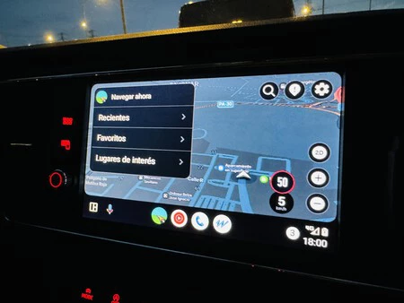
One of the things that I liked the most about its interface is the way to add destinations. As is usual in navigators for Android Auto, there is a magnifying glass to write them when the car is stopped or by voice commands if it is on the mark, but there are several very practical aces up its sleeve: ‘Recent’, ‘Favorites’ or ‘Places of interest’, where in my case I have found what I was looking for most of the time. And if you want to choose a specific specific destination that appears on the map, you can always touch the specific button that marks any point you choose, saving those specific coordinates
From here, we see other common on-screen buttons such as zooming in or out of the map, settings or the way to view the map, something that is useful for someone who tends to get distracted and does not orient themselves very well. Thus, you can choose between 3D, 2D and 2D map placing north in the upper areathe first being the one I liked the most because it gives an idea of the relief of the buildings when you walk through a city.
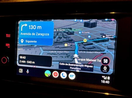
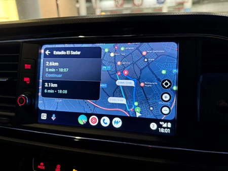
With the destination added, the street chosen and en route, we will see two speech bubbles: one with the estimated time of arrival, distance and time needed and another with the directions. They are large and take up a lot of space on the left of the screen, which is sometimes annoying, but at least they read well. By the way, if we touch the screen in the middle of the route, the ‘Finish’ button will appear to end the route.
Speaking of things that take up a lot of space on the screen, there is something that has been more uncomfortable for me: that it sometimes shows icons of gas stations and other businesses. It may be with the intention of speeding up the user experience in case you suddenly need a gas station, but In practice there are too many things on the screen. For example, what you see below these lines:
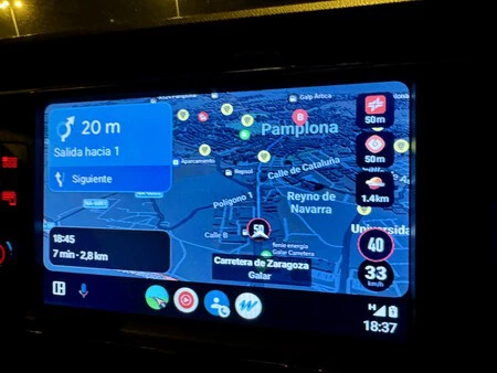
Another notable thing about its interface is that the pointer and the route are clearly visible on the route and that the choice of colors in both day and night modes are pleasing to the eye and do not lead to errors. By default, it signals the speed of the road we are going on, as well as the speeds on the main roads we are going to travel, which is good for avoid committing violations and drive more safely.
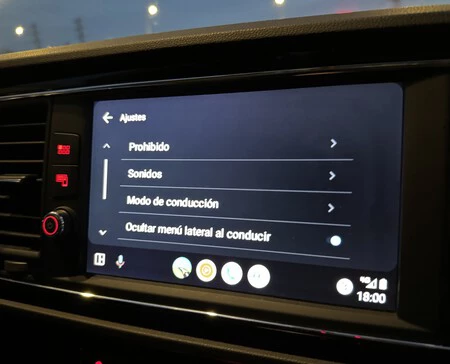
If the interface per se It is complete, the settings are not far behind: we can configure our driving preferences, simplify what we see on the screen, reduce sounds, change the way we get GPS data. In general, it has the basics and a few more things, which is appreciated if you are a demanding person looking for a personalized experience, although it is true that there are some screens in English.
Maps and incidents in real time
By testing this full version I have enjoyed its main strengths, which are what can lead us to pay for the application. Thus, the fact that the maps are updated monthly and we can download those that interest us seems important to me for people who
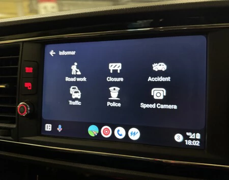
These days of use I have been moving around Pamplona and surrounding areas and the application has warned me of fixed and mobile radars, as well as other incidents that may occur en route. In fact, and if we need it, you can also witness accidents, police checks, traffic, construction… yes, this part of the app is in English (it doesn’t have much mystery thanks to the icons, but for example for my parents perhaps it would be a problem) and since the community is small compared to Waze’s, in practice it is not as updated.
I found it most useful that the voice notifications not only guide you, but also tell you when the speed limit changes, because normally you don’t look at the screen too much.
For
Also It has a simple and attractive interfacevoice navigation functions, speed limit change warnings and other features that make it easier to drive and discover new places.
Sygic Navigation on Android Auto, conclusions
Between the fact that I am a stingy for some things and that there are very good free browsers (of course, let’s not forget that any business is based on profitability, so there will be another way to monetize the experience, perhaps with user data or with ads), it’s hard for me to pay for an app. But if you use the car and Android Auto frequentlyI recognize that it may be worth it.
What I liked most about Sygic Navigation in Android Auto is that promise of monthly map updatesa feature that seems providential if, for example, you use your car daily to travel along new routes (I’m thinking of commercial and transport companies for example) and you also can’t risk running out of maps because there is no coverage.
I have also become fond of 3D maps, a function that Google Maps is incorporating and that is providential when you explore a new area. Speed guides and radars are also useful for safer driving. It is true that I would not choose Sygic for live information, but it is the fish that bites its tail: the more people use it, the more that area will be strengthened. However, today these real-time incidents in practice are light years away from Waze, a free browser.
Finally I want to highlight how complete it is both in terms of interface and options, even becoming too much for me. Of course, the colors depend on your taste: if you like personalization, it is a plus to take into account.

Sygic
GPS navigator and maps. One week free trial period


